Geography & Climate
 Geography
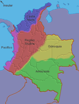
There are broadly five areas in Colombia that can be distinguished to climate and landscape.
-
The Andes Mountains in the West. Here lives the majority of the population mainly in the cities of millions like Bogota, Medellin and Cali. (Red)
-
The Caribbean coast. Also here are a few major population centers such as Cartagena and Barranquilla (Purple)
-
The Pacific Coast (Pink)
-
The plains of the Orinoco (Yellow)
-
The forest of the Amazon (the Orinoco and Amazon region covers 54% of the combined area of Colombia, but only 3% of Colombians lives there) (Green)
Climate
Colombia lies almost on the equator but because the height differences therer are four different climate zones. 83% of the country lies below 1000 meters with the average temperature is 24 °c. 9% of the land located between 1000 meters and 2000 meters with an average temperature of 18 °c. 6% of the land area is between 2000 and 3000 meters with an average temperature of 12 °c. Snow is found above 4500 meters altitude.
The seasons in Colombia are more characterized by rainfall than by temperature changes. In the low areas on the Caribbean coast (the north) there is a dry season from December to March, the rest of the year is rainy. In the south, the rainy season interrupted by a period of less rainy nature in June and July, and on the Pacific coast a dry season almost is non-existent.